One-way walking distance
Duration
Level of Intensity
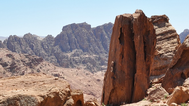
Sabra Trail
Trail
overview
For
those seeking an adventurous exploration of Petra’s diverse landscapes, the
Sabra Trail offers a rewarding journey through stunning scenery and rich
historical significance. This extensive hike should be started early in the
day. It begins at ez-Zantur (Pharaoh’s Column) and extends to Wadi Sabra,
located about 6.5 kilometers south of Petra. Historically, Wadi Sabra was
a
crucial caravan station on the route to Gaza. The trail features breathtaking
views of unique sandstone rock formations, sculpted over centuries by wind and
water into intricate patterns and dramatic cliffs. Hikers will also encounter
various desert plants adapted to the arid environment, such as juniper trees
and retama. Additionally, the trail passes ancient Nabataean tombs and
water
cisterns, offering a glimpse into the region’s rich history. Travelers may also
meet Bedouin shepherds and their flocks, enriching the cultural experience of
the journey. Due to its length and difficulty, it is advisable to use a guide,
wear sturdy hiking boots, and bring essentials like a hat, sunglasses,
sunscreen, ample water, and high-energy snacks. Hikers should be in good
physical condition; however, using camels for part of the journey can reduce
physical exertion and provide a traditional travel experience.
Trail
Details
Starting
Point: Petra/ez Zantur/Pharaoh`s Column
Endpoint:
Petra/Sabra
Category:
Heritage/Environmental/Geological
Distance:
7.9 Km/10367 Steps
Calories
Burn: 415 Calories
Duration:
3.15 - 3.30 Hours/Non-stop
Grade:
Moderate
Tour:
One-way
The
Pharaoh's Column
The
Pharaoh's Column is situated behind the Great Temple, forming part of an
unexcavated structure from a Nabataean sanctuary in ruins. Positioned along the
ancient route to Egypt via Naqb al-Ruba'i, the column comprises 11 stone drums,
with the lowermost one significantly eroded. Modern graffiti and scratches
adorn its surface. Mentioned frequently in accounts of 19th and early
20th-century travelers to Petra, the column is flanked by fallen drums,
suggesting its original towering height. Despite its current state of
disrepair, the Pharaoh's Column remains a significant archaeological and
historical landmark in Petra, bearing witness to the earthquakes of 363 and 551
that devastated the city.
The
Snake Monument
The
Snake Monument, a significant feature located in the southern part of Petra at
Ath-Thugra, is a sculptural representation featuring a rock-carved snake coiled
atop a block tomb, reminiscent of the Djinn blocks at Bab al Siq. Situated
along the route to Jabal Harun, it provides insights into the role of serpents
in Nabataean religious practices. The tomb itself is cube-shaped, representing
one of Petra's earliest sculptures, likely dating to the early second century
BC. According to legend, the snake was placed to protect the tomb from
burglars. The monument lies on the path to Jabal Harun and is positioned along
the ancient caravan route leading into Petra from southern Wadi Araba, Sinai,
Egypt, and the Negev.
In
the 19th century, numerous travelers, including Leon de Laborde and Linant de
Bellefonds, journeyed to Petra via this route. They arrived in Petra on March
28, 1828, during a period when a plague was rampant in the village of Wadi
Musa.
Wadi
Sabra Suburb
Wadi
Sabra, located approximately 7.5 kilometers south of Petra, served as a
significant suburb and caravan stop on the route to Gaza. This area features a
theater, a sophisticated water management system, and an acropolis mount,
showcasing Nabataean expertise in adapting to and controlling desert water
sources. Along the Petra-Gaza trade route, Wadi Sabra's watchtowers and
checkpoints were strategically placed to safeguard and regulate caravan traffic
through Wadi Araba. As a key stopover for caravans, Wadi Sabra's theater and
acropolis were prominent landmarks, complemented by several caravanserais like
Bir Madhkour, Ain Rahel, Qasr al-Mahle, and Oboda. These facilities provided
essential amenities such as shelter, food, and water for travelers and their
animals, fostering economic growth through trade and cultural exchange. For
instance, the limestone-block Ain Rahel caravanserai, measuring 16x16 meters,
featured eight rooms surrounding a central courtyard, illustrating the
infrastructure's functionality and design. Furthermore, the presence of these
caravanserais also facilitated communication and the exchange of goods between
different regions, contributing to the flourishing trade networks in the area.
The strategic location of Wadi Sabra along trade routes made it a crucial hub
for merchants and travelers alike, enhancing its significance in the ancient
world.
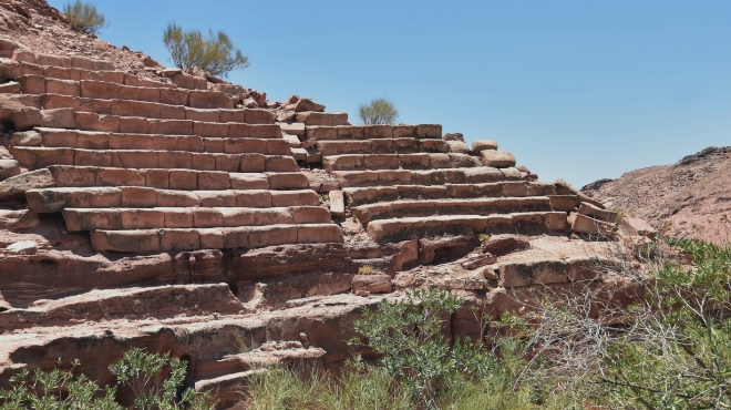
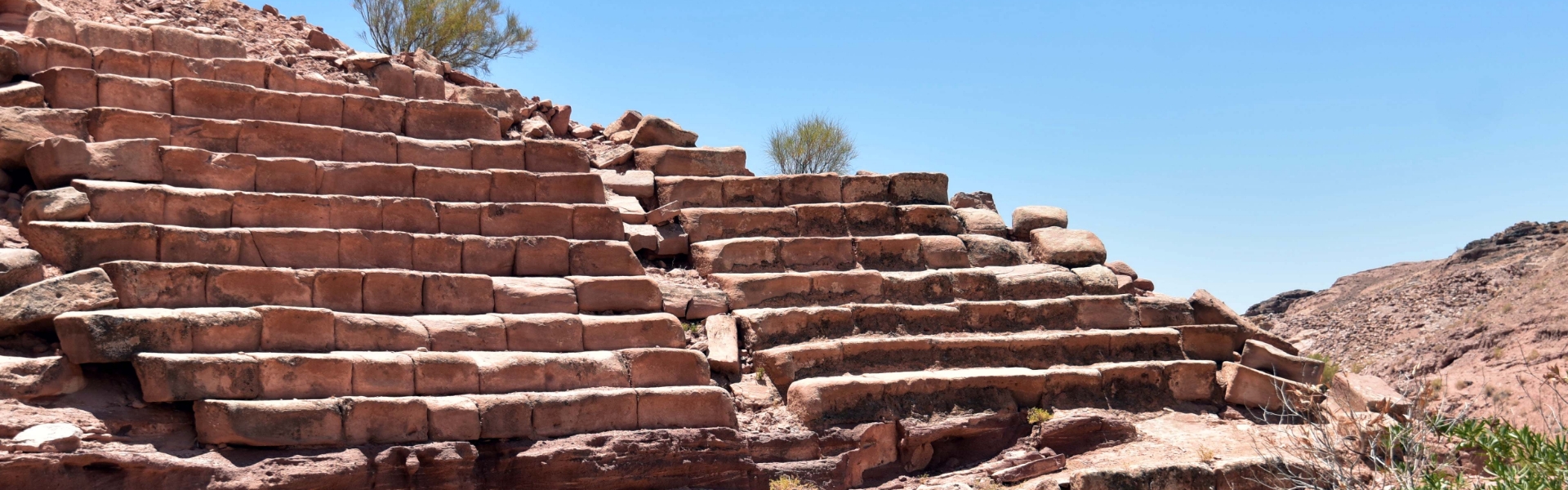
The
Sabra Theatre
The
Sabra Theatre exemplifies ancient Nabataean engineering prowess and cultural
significance. Located in a natural gully, the Sabra Theatre ingeniously
utilized the terrain to manage water, employing a sophisticated system of
channels and basins to control runoff. This small, horseshoe-shaped theater
measures 39 meters wide with an inner diameter of 22 meters, featuring tiered
seating accessible via stairways. Its 11 rows of seats could accommodate
between 500 and 800 spectators, indicating its use for celebrations, social
gatherings, and theatrical performances. Constructed in the 1st century A.D.
with additions like a large stairway in the 2nd century A.D., the theater
remained active until the late Roman period. Its strategic placement within the
suburban settlement of Sabra suggests it served as a central hub for community
activities, reflecting the area's importance as a caravan city along a major
trade route. The archaeological remains at Sabra underscore its role as a
thriving urban center deeply interconnected with regional trade.
The
Sabra Acropolis
Located
to the west of Jabal Jathum and the theater, the Sabra Acropolis was accessible
via a bridge across Wadi al-Muthaylija, a tributary of Wadi Sabra, with a dam
constructed on this stream. 19th-century plans labeled a monument surrounded by
porticoes as a temple. Recent archaeological work uncovered a paved floor with
a colonnade and a marble bust of an Oriental Aphrodite from the Late Roman
period. This discovery indicates that the site likely served as a religious
sanctuary, drawing pilgrims and worshippers. The presence of the Aphrodite bust
highlights the area's connection to the cult of Aphrodite and provides insight
into the religious practices of the time. The strategic location and
architectural features suggest its importance as a religious site in antiquity.
Further excavations and research will be essential to fully understand the
significance of the Sabra Acropolis in the region's history.
Sabra
and Abu Khushaybeh Copper Mines
Sabra,
located 7.5 kilometers southwest of Petra, thrived during the Nabataean period.
The site features significant Nabataean water management systems, a rock-cut
theater, and extensive metallic ore deposits, underscoring its role as a major
mining hub. Excavations in Wadi Sabra have uncovered copper-rich sandstones,
iron ore, and slag, indicating substantial copper mining and smelting
activities. Sabra was crucial in meeting Petra's non-precious metal needs. In
addition to Sabra, the region includes Abu Khushaybeh, strategically positioned
7.5 kilometers southwest of Petra. This site was a key stop for caravans
traveling between Petra and Wadi Araba. Notable copper mining sites in the
area—Wadi Abu Khushayba, Abu Qurdiyah, and Sabra—reveal the scale of Nabataean
copper production. Recent surveys have identified over 200 mining shafts and
several smelting sites, highlighting the extensive operations conducted in
ancient times. With its acropolis, theater, and advanced water systems, Sabra
was a thriving city that complemented Petra. Abu Khushaybeh played a vital role
in the caravan trade, particularly in copper. Geochemical studies show high
copper mineralization in the region, with Abu Khushaybeh deposits containing
0.65% copper. Although these deposits were not commercially exploited, they
were extensively mined by the Nabataeans and Romans.