One-way walking distance
Duration
Level of Intensity
Umm al Biyara Trail
Trail
overview
The
hike begins at a bend in the main trail at Rasasa and culminates at the summit
of Umm al-Biyara mountain. The initial section of the hike is likely the most
challenging, involving a steep ascent. Ascending to the peak of Umm al-Biyara
typically requires at least half a day. Sturdy walking shoes, sunscreen, a hat,
and ample water are essential due to the steep and demanding terrain,
especially in the heat of the day. The trail includes steep segments, but the
staircase leading to the summit is generally safe and well-maintained. Umm
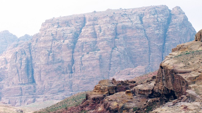
al-Biyara is the highest and most prominent mountain in Petra. An ancient
Edomite settlement was unearthed at its summit, and a Nabataean royal hilltop
residence added historical significance to the hike. The panoramic views from
the top justify the challenging ascent. Although reaching the summit is
strenuous, the vistas encompassing the ancient city center of Petra, the modern
town of Wadi Musa, Jabal Haroun, and Wadi al-Siyyagh make it worthwhile. The
ancient staircase leading to the summit has been restored.
Trail
Details
Starting
Point: Petra/Main Trail/al Rasasa
Endpoint:
Petra/Umm al Biyara
Category:
Heritage/Environmental/Geological
Distance:
2.6 Km/3412 Steps
Calories
Burn: 136 Calories
Duration:
2.30 - 2.45 Hours/Non-stop
Grade:
Moderate/Difficult
Tour:
One-way
The
kingdom of Edom
The
kingdom of Edom thrived from the 13th to the 8th centuries B.C., spanning from
the Wadi el-Hasa at the southern end of the Dead Sea to the Gulf of Aqaba in
the south. Despite its prosperity, the kingdom met its downfall when it was
destroyed by the Neo-Babylonians in the 6th century B.C. During the late Iron
Age, Jordan was home to three prominent kingdoms: the Ammonites in the north,
the Moabites in the center, and the Edomites in the south. Among these, the
Edomite Kingdom was particularly noted for its prosperity. The Edomites were
known for their fortified settlements and villages scattered throughout
southern Jordan, including notable sites such as Tawilan, Ba'ja, Busayra, Sela,
and al Mualaq. Notably, the settlement atop Umm al-Biyara (Arabic for
"Mother of Cisterns"), the highest mountain in Petra's urban area and
one of the most famous Edomite sites, serves as a testament to their hilltop
living during the late Iron Age.
The
Ancient Umm al-Biyara Processional Way
The
Nabataean processional way on the south-east side of Umm al-Biyara mountain is
adorned with rock-cut niches, believed to have been used for religious
ceremonies and processions leading to the sacred summit. These features
underscore its significance in the religious and social life of ancient Edomite
and Nabataean inhabitants. At the beginning of the ascent to Umm al-Biyara,
remnants of an arch that once spanned this monumental approach mark the start
of the ceremonial route up the mountain. A notable feature along this path is a
couloir—a massive double-flanking ramp carved into the mountainside—that stands
as a testament to the ceremonial significance of the ascent to the summit. Archaeologists
suggest that during the Edomite period, the summit was accessible only via an
extremely steep trail, predating the construction of Nabataean steps.
Significant efforts were undertaken by the Jordanian Department of Antiquities
in the 1990s and between 2001 and 2004 to clean, renovate, and enhance
accessibility to this route, transforming what was once a perilous and arduous
ascent into a more manageable journey for tourists.
Ruins
of the Ancient Edomite Settlement on Umm al-Biyara
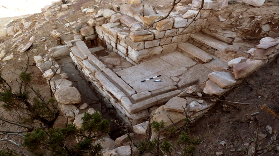
The
Edomite settlement of the 7th and 6th centuries BC atop the naturally fortified
rock of Umm al-Biyara, standing 1000 meters above sea level, underscores its
strategic significance for defensive purposes. Excavations conducted in 1960,
1963, and 1965 by Crystal Bennett of the British School of Archaeology revealed
a thriving community. The remains of houses and water cisterns indicate a
society sustained by agriculture and trade. Bennett's excavations uncovered an
unwalled site comprising drystone houses with long corridor rooms and smaller
square rooms. These dwellings were built adjacent to a continuous wall that
spanned the excavation area. Discoveries such as loom weights and spindle
whorls suggest domestic activities were prevalent. Numerous deep cisterns, likely
for water storage, were hewn into the peak. The discovery of a seal belonging
to Qos-Gabar, an Edomite king of the 7th century BC, further emphasizes the
historical significance of the site. Evidence suggests that the Edomite
settlement on the summit of Umm al-Biyara was destroyed by fire, marking a
significant event in its history.
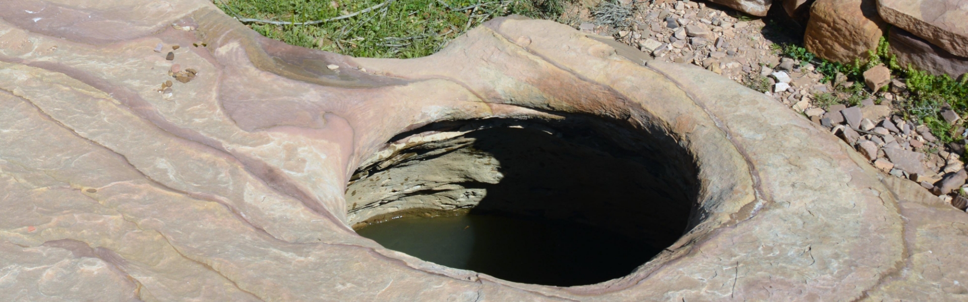
Umm
al-Biyara Cisterns
Umm
al-Biyara’ means 'mother of cisterns'. This archaeological site showcases
numerous piriform rock-cut plastered cisterns with circular openings and eroded
channels, along with several large basins 6 meters deep. Near the eastern edge
of the plateau, eight rock-cut piriform cisterns with rainwater channels were
discovered. The piriform-shaped cisterns atop Umm al-Biyara in Petra are 4
meters deep and 6 meters wide. These installations were crucial for catching
rainwater and supplying water to the settlement. At the summit of Umm
al-Biyara, there is no natural water source; if the rock-cut water cisterns
have been depleted or consumed, all water must be carried up from the springs
and wadis of the Petra basin. The strategic placement of these cisterns and
basins ensured a reliable water supply for the inhabitants. The presence of
such sophisticated rock-cut features indicates an advanced water management system
at 'Umm al-Biyara'.
Nabataean
Structures on Top of Umm al-Biyara
Excavations
conducted by the International Umm al-Biyara Project (IUBP) between 2010 and
2014 revealed that the Nabataeans constructed a series of structures around the
first century BC. These structures were built on the eastern side, right on the
edge of the rock, and occupy the hill's most prominent spots. They provided a
stunning view of Petra and could be seen from the city center and beyond.
Excavations also revealed that the buildings on the eastern side of Umm
al-Biyara were reused throughout the Roman period, before being destroyed by an
earthquake in 363 CE. The most visible structure is a royal palace, with
limestone floors and decorative marble walls that served the Nabataean elite,
most likely the kings. It has several luxurious rooms, including one with a
hypocaust floor-heating system that extends into the walls. A small aqueduct
fed water into a basin on the southern side. These amenities, accompanied by
the presence of bathtubs and latrine structures, reflect the high status of the
occupants. A Nabataean king enjoyed a panoramic view of the capital from a high
point, with the rest of the plateau, except for some watchtowers, largely
unoccupied.
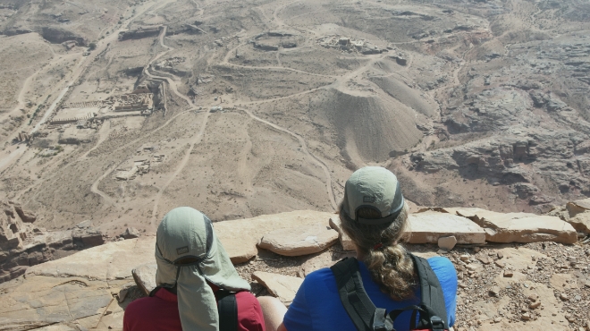
The
Panoramic View from Umm al-Biyara
The
Petra City Center panorama offers a breathtaking 360-degree view of the ancient
city from the top of the Umm al-Biyara plateau. It showcases the iconic royal
tombs carved into the rose-red cliffs, along with the vast expanse of the
surrounding landscape. Visitors can also admire the intricate natural rock
formations, rock-cut architecture, and tombs that make Petra a UNESCO World
Heritage Site. Additionally, visitors can explore the ancient Nabatean ruins
and learn about the history and culture of this once-thriving city.
The
panoramic view from Umm al-Biyara vividly captures the essence of Petra's
beauty and historical significance, offering a breathtaking glimpse into its
rich history and unique architecture at the City Center. It is a must-see for
anyone visiting this ancient wonder of the world. This remarkable viewpoint
allows one to fully appreciate the grandeur and splendor of Petra from a unique
perspective. For tourists, the view from Umm al-Biyara offers a memorable and
immersive experience that enhances their visit. From a marketing standpoint,
this vantage point is invaluable in promoting Petra as a premier travel
destination, showcasing its unmatched beauty and historical depth.